Real Estate Maps
PROFESSIONAL RURAL PROPERTY MAPS THAT SELL
High-impact visual assets for rural listing, grazing blocks, and acreage. Delivered fast, Australia-wide. Our real estate maps are great for marketing and selling properties. They provide accurate representations of property boundaries, features, and layouts, helping potential buyers understand the value and characteristics of the land.
Map Types
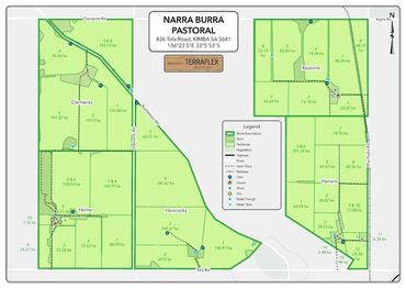
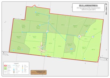
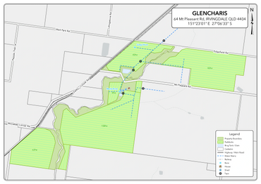
PROPERTY MAP - Our property maps are meticulously crafted to elevate the appeal and marketability of your property. They highlight a comprehensive array of features including property boundaries, cadastre, and paddocks complete with name and size details. Additionally, our maps showcase roads, tracks, houses, sheds, bores, dams, and irrigation lines. We also specialise in farm mapping, providing detailed representations of fields, crops, irrigation systems, livestock areas, and any other agricultural elements you wish to highlight. We can tailor the map to include any other specific features you wish to highlight, ensuring that every aspect of your property is presented in the best possible light.
AERIAL MAP - Aerial Maps provide a detailed and comprehensive view of landscapes, facilitating accurate navigation, emergency response, and precise environmental monitoring. Their high-resolution imagery is instrumental in applications such as surveying, precision agriculture, and infrastructure planning, offering valuable insights for diverse fields and applications.
LOCATION MAP - Location maps are invaluable tools for providing a broad understanding of a property's geographic context. They illustrate the property's position relative to nearby towns, cities, and local government areas, giving a clear picture of its surroundings. These maps are particularly useful for navigation, helping customers and contractors determine the best routes and access points to the property. By showing key infrastructure and connections, location maps ensure smooth and efficient travel planning, making it easier for everyone to find and reach your property.
VEGETATION MAP - Vegetation maps are crucial for property planning and purchasing. They show different categories within the vegetation management framework, helping you identify areas that can and cannot be cleared. Understanding these categories ensures regulatory compliance and informed decision-making. Our detailed maps provide the information you need to navigate land use regulations effectively.
Please note that our prices are exclusive of GST, as no GST is being charged.
Examples
Copyright © 2026 Terraflex Mapping - All Rights Reserved.
This website uses cookies.
We use cookies to analyse website traffic and optimize your website experience. By accepting our use of cookies, your data will be aggregated with all other user data.